
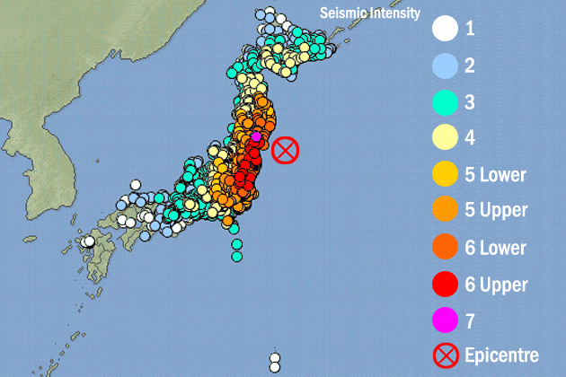
 NSDL makes available a wealth of high quality resources to enrich a “teachable moment” about the devastating earthquake, tsunami, and nuclear emergency that Japan is suffering since last Friday, March 11, 2011. You can find high resolution images in the Earthquake rocks Japan resource, and maps explaining the propagation of tsunami waves in Tsunami hits Japan after massive quake from the Teach the Earth: SERC Portal for Geoscience Educators. Earthquake Research Institute, University of Tokyo, from Internet Scout, is another valuable resource. For computer interactives to understand how an earthquake epicenter is located and how the Richter magnitude of an earthquake is determined, take a look at Virtual Earthquake, an interactive web-based program provided by DLESE. They also offer the DLESE Earth Science Literacy Maps, a great tool to aid the teaching and learning of Earth system science, showing relationships between concepts, how concepts at a given level connect with and emerge from concepts at prior levels, and links to related National Science Education standards information. In addition, the NSDL Science Literacy Map on plate tectonics allows users to browse a variety of resources including lesson plans, interactives and multimedia, for teaching and learning about these phenomena. Finaly, ALSOS, the Digital Library for Nuclear Issues offers a link to NOW: Nuclear Plant Security.
Teachable moments: earthquake, tsunami, and nuclear worries …
Wednesday, March 16th, 2011 2:34 pm
Written by: Brad Edmondson
Posted in Topics: General
Both comments and pings are currently closed.
Categories
Previous Posts
- July 2011
- June 2011
- May 2011
- April 2011
- March 2011
- February 2011
- December 2010
- November 2010
- October 2010
- September 2010
- July 2010
- June 2010
- April 2010
- March 2010
- February 2010
- January 2010
- December 2009
- November 2009
- October 2009
- September 2009
- August 2009
- July 2009
- June 2009
- May 2009
- April 2009
- March 2009
- February 2009
- January 2009
- December 2008
- November 2008
- October 2008
- September 2008
- August 2008
- July 2008
- June 2008
- May 2008
- April 2008
- March 2008
- February 2008
- January 2008
- November 2007
- October 2007
- September 2007
- August 2007
- June 2007
- May 2007
Content distributed under:

* You can follow any responses to this entry through the RSS 2.0 feed.