This blog is focused on helping elementary teachers become more knowledgeable about the polar regions and providing best practices on how to integrate polar concepts into their teaching. Ideas for connecting science and literacy through literature and writing, exemplary science activities, incredible pictures, tales of adventure, and stories of indigenous people and amazing animals will be part of each posting.


Contributors:

Polar News & Notes: Upcoming Opportunities

The National Science Teachers Association (NSTA) is holding three free web seminars on the International Polar Year and the living systems in the Arctic and Antarctic. The presenters’ scientists and educators– will share their expertise, answer questions, and provide information that can be used in elementary and middle school classrooms. Each seminar is a stand-alone program. All 90-minute sessions are live and held from 6:30 to 8 p.m. EST on Thursdays. The dates and presenters are:

Seminar I - December 20, 2007 — Dr. Brendan Kelly , program director for Arctic Biology in the Office of Polar Programs at the National Science Foundation (NSF).

Seminar II - January 17, 2008 — Dr. Kathy Gorski, middle school teacher and now an Einstein Fellow in the Office of Polar Programs, NSF.

Seminar III - January 24, 2008 — Dr. Craig Tweedie, professor of biological and environmental sciences with research experience in Antarctica.

Register with NSTA to receive an e-mail confirmation, information about the seminar program, and suggested links to visit in preparation. If you cannot participate in the live sessions, you will be able to find them after the event in the Web Seminars Archive.

Posted in Topics: Education, Polar News & Notes, Professional Development, Science, Technology

No Comments

Mapping the Polar Regions

Globe Puzzle photo taken by batintherain; subject to a Creative Commons license

Did you know that while the Arctic is an ocean surrounded by continents, Antarctica is a continent surrounded by oceans? While this sounds like a simple play on words, it represents a profound difference in the geography, climate, and ecology of the two regions.

Did you know that the polar regions are more than just the North Pole and South Pole? The regions actually encompass the areas north of Arctic Circle and south of the Antarctic Circle, respectively. The Arctic thus encompasses the Arctic Ocean as well as portions of eight countries: Norway, Sweden, Finland, Russia, the United States, Canada, Denmark (the territory of Greenland), and Iceland. In comparison, the Antarctic encompasses the continent of Antarctica and portions of the South Atlantic, South Pacific, and Indian Oceans.

Did you know that some maps display a distorted representation of the polar regions? For example, the commonly used Mercator projection presents an accurate view of the equatorial regions but is distorted at both poles. On this type of map, Greenland is about the size of Africa. In reality, Africa is 14 times the size of Greenland! Additionally, the world map commonly used in textbooks and classrooms shows only a portion of Antarctica and does not represent the continent’s true shape. Viewing more accurate representations is the first step in teaching and learning about these two dramatically different, yet often confused areas.

Why teach about the polar regions, their geography, and maps?

These concepts seem to belong in a social studies unit, and, indeed, they do fit within the National Council for the Social Studies strand of People, Places and Environment. But science educators place great importance on recognizing, challenging, and correcting student misconceptions. Any incorrect ideas about the basic size, shape, and location of the Arctic and Antarctic will definitely impact students’ understanding of the science of the two regions. These concepts are best viewed as part of an interdisciplinary unit that integrates basic science, geography skills, and literature.

Lessons about the North and South Poles can also be extended to include the concept of magnetism. The Earth’s magnetic field is the basis for natural phenomena such as the aurora borealis, is believed to play a role in animal migrations, and is used to aid travel and communication. According to the Physical Science content standard of the National Science Education Standards, K-4 students should develop an understanding of light, heat, electricity, and magnetism. Hands-on experiments with magnets in the primary grades lead to an understanding of magnetic fields and compasses in the upper grades. Although most elementary students will not understand the difference between the magnetic poles and geographic poles, they can be introduced to the idea that the Earth has a magnetic field, which has been used in exploration throughout history. (Read the entire National Science Education Standards online for free or register to download the free PDF. The content standards are found in Chapter 6.)

Teaching the Concepts

Mapping

Students in grades K-2 should first be introduced to globes and maps. A literature-based lesson that introduces the need for maps is based on the book I Hate English by Ellen Levine. Although this book does not discuss the polar regions, it does present the idea of using maps to show direction. Following this lesson, students can use globes and maps to locate the North Pole and South Pole and learn the four cardinal directions. The National Geographic lesson “Getting Lost” can be modified to include the poles and provides additional practice in using cardinal directions. Although transitioning from a globe to a map can be challenging, it is important for students to practice using both representations. Teacher-led discussions can assist students in understanding the differences between maps and globes, as well as the advantages and disadvantages for each.

Once students have developed a basic geographical understanding of the poles, they can begin to learn about each region’s characteristics. The book North Pole, South Pole will help students compare and contrast the two poles. Characteristics of the poles can be recorded on a T-chart as a class, in small groups, or individually.

Students in grades 3-5 should be familiar with globes and maps. In addition to locating the poles and reviewing cardinal directions, students are ready to use latitude and longitude and explore the differences between maps and globes. The lesson plan “Yarning About Latitude and Longitude” uses a whole-class, kinesthetic activity to introduce the concepts of latitude and longitude as well as the Equator, Arctic Circle, and Antarctic Circle. Two original songs (sung to the tune of “The Wheels on the Bus”) can help students remember the difference between latitude and longitude.

Students at the upper elementary level can also begin to explore map projections. Peeling an orange is a simple way to demonstrate the challenges of showing a curved surface on a flat map. Students can also begin to understand the distortion of map projections by creating a globe and a map with a tennis ball covered with paper. Both of these activities can be challenging and may frustrate your students. It may be helpful to perform these as a demonstration instead of a hands-on activity. Follow these activities or demonstrations with a comparison of a traditional Mercator projection and a polar map. National Geographic has a downloadable map for Antarctica, or you can use a globe. Have students record the similarities and differences in a graphic organizer such as a Venn diagram or T-chart.

The book Poles Apart: Why Penguins and Polar Bears Will Never Be Neighbors is an appropriate introduction to the polar regions for upper elementary students. Students can record information on a T-chart, or compare and contrast using a Venn diagram. Use a single chapter as a read aloud, as the text is dense! Less proficient readers will still benefit from the information in North Pole, South Pole.

Magnetism

Students in grades K-2 should be given time to explore magnets and their properties. Students can test a variety of materials, classifying them into “Magnetic” and “Non-magnetic” groups. Through experimentation, students will begin to notice patterns in magnetic and non-magnetic materials. Students may also notice a magnet’s polarity. Encourage students to record their observations, and ask questions.

An introductory lesson on polarity for students in grades 3-5 involves identifying and describing the poles of a magnet as well as demonstrating how the poles interact with one another. Students can also explore Earth’s magnetic field through the Exploratorium’s Science Snack: Magnetic Lines of Force. In this activity, a bar magnet is suspended inside a clear soda bottle. Iron filings inside the bottle form a 3-D magnetic field. This mess-free activity is a great way to introduce and visualize the Earth’s magnetic field. Students can then create their own compass. The web site “How Stuff Works” provides background information on Earth’s magnetic field and instructions for creating a simple magnetic compass.

Suggested Readings

Our highlighted books use physics, geography, and biology to explore some of the properties shared by the two ends of the Earth’s axis and other ways in which they are poles apart.

North Pole South Pole. Nancy Smiler Levinson. 2002. Picture book. Recommended ages: K-2.

Poles Apart: Why Penguins and Polar Bears Will Never Be Neighbors. Elaine Scott. Penguin Young Readers Group. 2004. Picture book. Notable Social Studies Trade Books (2005). Recommended Ages: Upper Elementary, Middle School.

Literacy Connection

Many of the activities described above include the skill of comparing and contrasting. Appropriate for all students in grades K-5, this is a crucial skill used in almost every content area. Many resources exist for using this strategy at developmentally appropriate levels. We’ve chosen to highlight a few here.

ReadWriteThink provides a lesson plan for introducing Venn Diagrams in the Kindergarten classroom. Students could use the Venn Diagram to sort magnetic and non-magnetic materials. The web site also provides an interactive Venn Diagram. Students type their concepts and drag them into the appropriate part of the diagram. Please note that you must print the diagram to see all of the student’s text!

Houghton Mifflin’s Education Place provides a printable T-chart. Students can use this to record characteristics of the Arctic and Antarctic, rather than phrasing them as similarities and differences. This type of chart is a useful note-taking tool and can be used before completing a Venn diagram.

Back to You

What about you? Do you have a favorite geography resource, lesson plan, or book that you’d like to share? What about exemplary student work (without identifying information, of course)? This site won’t be at its best unless we have input from you — the people who make these ideas come alive to your students everyday! Please post a comment to this blog with suggestions, tips, or comments.

And of course, please check back often for our newest post, download the RSS feed for this blog, or request email notification when new content is posted (see right navigation bar).

That’s it for this time! Until next time, stay cool with this hot topic!


Posted in Topics: Antarctica, Arctic, Education, Reading, Science, Writing, social studies

View Comments (2) »

Polar News & Notes: Antarctic Tourism

Did you know that you can take a cruise to Antarctica? You can land at a penguin rookery, kayak, hike, or even camp overnight on the seventh continent’s ice. What was once reserved for the bravest explorers and scientists is now available to anyone willing and able to pay.

Adv in AntarcticaA quick Google search lists many tour companies offering cruises and activities in Antarctica. Prices vary dramatically, with trips ranging from about $4,000 to over $20,000. Yet these “experiences of a lifetime” could come at a much greater cost, as evidenced by the recent sinking of a Canadian-owned cruise ship off King George Island.

photograph by INTTraveler; subject to a Creative Commons license

Antarctica is the largest wilderness area on Earth, and is protected by the Antarctic Treaty. Originally signed in 1959 and bolstered by other agreements ratified over the years, the treaty states that the area should only be used for peaceful purposes and that the environment, including plants, animals, and historic sites, should be preserved.

The International Association of Antarctica Tour Operators has developed a set of guidelines for tour operators to ensure environmental protection and safety. Approximately 95% of tour companies who offer trips to Antarctica are members of this association. While the association remains committed to reducing environmental impact, there is still the possibility of companies who do not follow the more stringent requirements set by the IAATO. And even if these requirements are followed, accidents can and do occur.

The IAATO reports that 37,552 tourists visited Antarctica in 2006-2007. While this number pales in comparison to other tourist destinations (Disney World’s Magic Kingdom reported 16.6 million visits in 2006), the reality is that the number of visits to Antarctica is increasing every year. More visits mean a greater possibility of environmental impact through the introduction of non-native species, waste disposal, and marine pollution. Additionally, the risk of a large vessel sinking in Antarctic seas poses both human danger and an environmental catastrophe. Currently, the sunken cruise ship is leaking diesel fuel, and bad weather has prevented experts from containing the spill. Marine biologists have been unable to assess the impact of the spill on plankton, fish, and krill — all important parts of the Antarctic food chain. Marine biologists also worry that the spill will impact Antarctic, Adelia, and Papua penguins whose breeding grounds are located near the site of the spill.

However, there’s no denying the lure of Antarctica. Who wouldn’t love to see a colony of Emperor penguins, watch whales feeding, and glaciers calving? And in the midst of an International Polar Year and a time of dramatic change in the Arctic and Antarctica, many in the scientific community are bemoaning a lack of knowledge and/or interest in the polar regions. If environmentally responsible travel can generate that interest and correct some misconceptions, might it really be a positive?

What do you think? Read about it, think about it, talk about it. Post your comments here — we’d love to hear from you!

Posted in Topics: Antarctica, Current News, International Polar Year, Oceans, Polar News & Notes, Science

View Comments (7) »

Polar Bears: Much More than a Polar Pin-Up

Polar Bear A photograph by Spiritwood Images; subject to a Creative Commons license

Did you know that polar bears live only in the Arctic? Many people wonder why polar bears don’t eat penguins, another animal popularly associated with the poles. In fact, these two animals live at the opposite ends of the earth! The giant marine mammals are believed to have evolved from brown bear ancestors approximately 200,000 years ago. They are found in five nations that extend above the Arctic Circle: the United States (Alaska), Canada, Russia, Denmark (Greenland), and Norway.

Did you know that polar bears really aren’t white? Each hair is a transparent, hollow shaft. The hollow core scatters and reflects visible light in the same manner as ice and snow do, causing the hair to appear white in color. Beneath the dense fur is black skin! A common myth is that this transparent hair acts as a fiber-optic guide to conduct light to the black skin where the energy can be absorbed. This theory was tested and disproved by physicist Daniel W. Koon in 1988. In his study, Koon found that the keratin protein in the hair actually absorbs much of the light before it ever reaches the skin.

A bear’s real insulation comes from its dense fur and a thick (up to 4.5 inches) layer of blubber. This insulation is so effective that overheating is a much bigger problem than heat loss. In fact, polar bears give off so little heat that they do not show up in pictures taken with infrared film. (Infrared film detects and records the amount of heat.) The only visible spot in such a picture would be the puff of air caused by the bear’s breath!

Did you know that polar bears are a vulnerable species in today’s changing world? While human impact (industrial processes, poaching, and pollution) are affecting bear populations, a loss of sea-ice habitat due to climate change is the greatest threat. Scientists predict that if current warming trends continue, two-thirds of the polar bear population could disappear by 2050. Others predict that the polar bear species may become extinct within 100 years.

Why Teach about Polar Bears?

Like penguins, polar bears are well-known polar animals. The cuddly looking bears have starred in many cartoons, commercials, and movies. But student understanding often stops with these simplistic images, or includes the misconceptions described by Polar Bears International. In fact, polar bears are fascinating creatures, well adapted to life in a harsh climate.

According to the Life Science content standards of the National Science Education Standards, K-4 students should develop an understanding of the characteristics of organisms, life cycles, and how organisms depend on their environments. Students in grades 5-8 should develop an understanding of structure and function in living systems, reproduction and heredity, regulation and behavior, populations and ecosystems, and diversity and adaptation of organisms. Including lessons or a unit on polar bears in your teaching is a great way to address topics such as camouflage and adaptation, which are included in the Life Science Standards for both elementary and middle school. You can also use the topic to illustrate how human activities and climate change can impact polar bear populations.

Teaching the Science

You may want to learn more about polar bears before introducing the topic with your students. Polar Bears International is a conservation and education group dedicated to protecting polar bears throughout the Arctic. Its web site provides a wealth of factual information, interactive features such as polar bear cams and bear trackers, current research information, and ways to get involved. Some of these features may also be appropriate for use with your students.

For K-2 students, science and literacy are heavily integrated in the following lessons. You may notice that many of these lessons include the idea that polar bears are white. While we do not want to promote misconceptions, the transparent hair of polar bears does, in fact, appear white. In this case, teaching the correct science may be too advanced for these youngest students. If you feel it is appropriate, you can introduce the idea, using snow or ice as a more concrete example of an object that appears white, but really isn’t.

In Why Are Polar Bears White?NSDL Annotation, K-2 students learn about the concept of camouflage through a hands-on activity. They then apply this concept by creating a picture of a polar bear to demonstrate why its color is a helpful adaptation.

The lesson Polar Bears: Keeping Warm at the ArcticNSDL Annotation is designed for students in K-1 but could be modified for older grades as well. Students visit a local zoo to observe a polar bear, recording observations in a lab notebook. (If a field trip is not an option, video highlightsNSDL Annotation such as the ones from National Geographic’s Polar Bear Cam could substitute.) Students then create a “blubber glove” with plastic bags and a shortening product, such as Crisco. By placing a gloved hand and a non-gloved hand in ice water, they can observe the insulating properties of blubber firsthand. Students communicate their findings through art, discussion, and writing. (This lesson is subject to a Creative Commons license.)

For students in grades 4-5, ThinkQuest has a one-page introduction to polar bearsNSDL Annotation as part of a larger site about Arctic animals. This, along with Polar Bears International, could be a good introduction to the species before doing research or a hands-on activity like Polar Bears and their Adaptations.

A hands-on lesson designed for students in grades 4-5 is Polar Bears and their AdaptationsNSDL Annotation. After an introductory discussion of the concept of adaptation, students create a “blubber glove” with plastic bags and a shortening product, such as Crisco, and test in ice water. Students write about the experiment and their results, which are assessed through a rubric. (This lesson is subject to a Creative Commons license.)

Students in grade 4 and up can also investigate the effects of climate change on polar bear populations in Bearly Any IceNSDL Annotation. This lesson provides background information at a variety of levels and involves a modified version of tag to simulate the predator-prey relationship between polar bears and ringed seals. Playing this game will help students understand the drastic impact of global warming by linking the amount of sea-ice and the sea ice season to the survival of the polar bear. Before participating in this activity, students should have a good understanding of climate change and the habitat and hunting behavior of polar bears. Lesson extensions could utilize the many current news articles which discuss the changes in sea-ice and the impact on polar bears’ survival.

Suggested Readings

There are many wonderful stories about polar bears. You may have books in your own collection, or your media specialist may be able to suggest favorites. We’ve chosen to highlight three award-winning books here.

Ice Bear: In the Steps of the Polar Bear. Nicola Davies. Illustrated by Gary Blythe. Candlewick Press. 2005. 32 pp. NSTA Outstanding Trade Book (2006). Recommended ages: Primary, Elementary.

Polar Bear Night. Lauren Thompson. Illustrated by Stephen Savage. Scholastic Press. 2004. Picture book. New York Times Best Illustrated (2004). ALA Notable Books for Children (2005). Charlotte Zolotow Honor (2005). Recommended Ages: Emerging Readers, Primary.

Snow Bear. Jean Craighead George. Illustrated by Wendell Minor. Hyperion. 1999. Picture book. Notable Books of the English Language Arts (2000). Recommended Ages: Primary.

Literacy Connection

ReadWriteThink has an online Animal Inquiry tool. This is an interactive graphic organizer in which students can record information about basic facts, animal babies, interaction with others, and habitats. The site includes suggestions for classroom use, as well as links to other integrated reading, research, and report-writing lessons that use the tool. While these lessons are all designed for K-2 students, they can be easily modified for use in upper elementary as well.

Back to You

What about you? Do you have a favorite polar bear resource, lesson plan, or book that you”d like to share? What about exemplary student work (without identifying information, of course)? This site won’t be at its best unless we have input from you — the people who make these ideas come alive to your students everyday! Please post a comment to this blog with suggestions, tips, or comments.

And of course, please check back often for our newest post, download the RSS feed for this blog, or request email notification when new content is posted (see right navigation bar).

That’s it for this time! Until next time, stay cool with this hot topic!

Posted in Topics: Animals, Arctic, Education, International Polar Year, Lesssons and activities, Life Science, Reading, Science, Writing

View Comments (5) »

Polar News & Notes: Japan’s Whaling Expedition

Did you know that a Japanese whaling fleet departed the port of Shimonoseki on Sunday, heading toward the waters off Antarctica to hunt humpback whales? These whales, once nearly extinct and listed as an endangered species, are now listed as “vulnerable” by the World Conservation Union. Their worldwide population is estimated in the range of 30,000 to 40,000. This hunt would be the first since the 1960s, when a 1963 moratorium put the whales under protection.

Humpback Whalephotograph by Giles Shaxted; licensed under a Creative Commons Public Domain license

Japan aims to take 50 humpbacks as well as up to 935 minke whales and 50 fin whales in a scientific expedition in order to study reproductive and feeding patterns. Once killed, meat from the whales will be sold on the commercial market in accordance with International Whaling Commission requirements.


Critics state that there are research methods that do not require killing and allege that this is a commercial whaling expedition disguised as a scientific venture. The U.S. Department of State recognized Japan’s legal rights but also asked Japan to refrain from the hunt. Greenpeace plans to shadow the fleet to try to reduce their catch. The conservation organization recently announced a satellite-based tracking system to monitor the whales as an alternative to killing them.


What do you think? Is this a scientific expedition or just a commercial venture? Is this just an example of cultural misunderstanding, or truly a conservation issue? How can we know that a scientific study is really what it claims to be? Read about, think about it, talk about it — we’d love to hear from you!

Posted in Topics: Polar News & Notes, Science

View Comments (2) »

Sunrise, Sunset: Learning About Seasons

Did you know that Anchorage, Alaska, experiences approximately 19 hours of daylight on the summer solstice? Or that in Barrow, Alaska, the sun does not set for 84 continuous days during the summer (approximately May 10-August 2)?Midnight Sun in Fairbanks, Alaska


Did you know that summer temperatures in Fairbanks, Alaska, can reach 100+ degrees Fahrenheit? Or that Alaska’s short but intense growing season can produce giant vegetables such as cabbages weighing over 100 pounds and pumpkins weighing over 1,000 pounds?

Many people think of Alaska (and the entire Arctic region) as a place of cold, snow, and darkness. And for a portion of the year, that is true. On the winter solstice (Dec. 21), Anchorage experiences about 5 hours of daylight. Residents of Barrow say goodbye to the sun on Nov 18. They won’t see the sun rise again until January 22!

SnowWhile temperatures tend to be milder in Anchorage due to the coastal location, winter temperatures in Alaska’s interior can drop to 40 degrees below zero. Brr!

Seemingly endless sunlit days in summer and winter nights that never end, Alaska and the entire Arctic region experience huge fluctuations in seasonal amounts of daylight and temperature. Teaching about these extremes can help your students understand the cause of seasons.

Why teach about seasons?

The cause of our Earth’s seasons is the subject of many misconceptions. Research has shown that even some college graduates and teachers were unable to correctly identify the cause of seasonal change. The National Science Digital Library’s Middle School Portal provides more information about these misconceptions.

The most common misconception is that earth is closer to the sun during the summer and farther away during winter months. Science U’s observatory page includes a discussion of this misconception and why it isn’t correct.

So why do we have seasons? It all comes down to the earth’s axis.

Earth’s tilted axis means that as the earth revolves around the sun, the northern and southern hemispheres receive more direct sunlight at different times of the year. More direct sunlight leads to higher temperatures, resulting in summer for that part of the world.

The cause of seasonal change is listed in the National Science Education Standards as an Earth and Space Science content standard for grades 5-8. However, it is recommended that students in K-4 develop their observational and descriptive skills. Comparing and contrasting seasonal amounts of daylight and temperature between the student’s home and a location in the Arctic will build the necessary foundation for this difficult concept. These concepts also tie nicely into a study of geography and climate, which is often part of elementary social studies curricula. (Read the entire National Science Education Standards online for free or register to download the free PDF. The content standards are found in Chapter 6.)

Teaching the Science

Two online articles from NSTA’s Science and Children journal show how to integrate literacy and the science of the seasons. All lessons use trade books to introduce a concept that is further developed through inquiry activities. To access these free articles, you will first need to log in to the NSTA web site. Creating an online account with NSTA is free.

In “Seasons by the SunNSDL Annotation“, students in K-3 read Sunshine Makes the Seasons and then trace and measure their shadows seasonally. Teachers can lead their students to reflect on and compare their observations. Students in grades 4-6 read Arctic Lights, Arctic Nights and record data from the story on a data sheet. Follow-up discussion and activities allow students to represent data graphically and begin to understand the connection between the seasons and day length. Students can then extend their understanding by collecting and graphing information for their hometown.

In “A Season to InquireNSDL Annotation“, students in K-3 read Four Seasons Make a Year. They then draw a schoolyard scene repeatedly through the year, measuring shadow lengths, comparing observations, and making predictions and connections with each new observation. Students in grades 4-6 read Autumn (Winter & Spring) Across America, a three-book series by Seymour Simon. Students then investigate changes in temperature as a flashlight is held at different angles. The observed pattern, that direct light results in greater temperatures, can help students begin to explain the change in seasons and the difference between temperatures in their hometown and other locations.

The U.S. Naval Observatory web site can compute a sunrise/sunset table for any location worldwide for a one-year period. The table itself isn’t kid-friendly, but it does provide an excellent data source for teachers wanting to compare seasonal changes for a variety of locations.

Suggested Readings

These titles are incorporated into the “Seasons by the Sun” and “A Season to Inquire” lessons mentioned above. You may have other exemplary books in your own library, or your media specialist may be able to recommend titles.

Sunshine Makes the Seasons. Franklyn M. Branley. Illustrated by Michael Rex. HarperCollins. 2005. 31 pp. Recommended Ages: Primary.

Four Seasons Make a Year. Anne Rockwell. Illustrated by Megan Halsey. Walker & Company. 2004. 32 pp. Recommended Ages: Primary.

Arctic Lights, Arctic Nights. Debbie S. Miller. Illustrated by Jon Van Zyle. Walker Publishing. 2003. (Unpaged). NSTA Outstanding Trade Book (2004). Recommended Ages: Elementary.

Autumn Across America. Seymour Simon. Hyperion. 1993. 32 pp. Recommended Ages: Elementary.

Winter Across America. Seymour Simon. Hyperion. 1994. 32 pp. Recommended Ages: Elementary.

Spring Across America. Seymour Simon. Hyperion. 1996. 32 pp. Recommended Ages: Elementary.

Literacy Connection

The NSTA resources provided above incorporate many valuable literacy skills. Reading and discussing quality trade books expose students to scientific content and expository text. These books provide a great opportunity for reading comprehension activities and vocabulary development. Furthermore, the journaling and observational activities that follow each book require students to write and discuss their ideas with peers and teachers.

Back to You!

What about you? Do you have a favorite resource, lesson plan, or book that you’d like to share? What about exemplary student work (without identifying information, of course)? This site won’t be at its best unless we have input from you — the people who make these ideas come alive to your students everyday! Please post a comment to this blog with suggestions, tips, or comments.

And of course, please check back often for our newest post, download the RSS feed for this blog, or request email notification when new content is posted (see right navigation bar). We’ll alternate these longer posts with shorter posts called “Polar News & Notes.” Instead of providing lessons and activities for your classroom, “Polar News & Notes” posts are designed for you - a chance to learn and reflect.

That’s all for now! Until next time, stay cool with this hot topic!

Posted in Topics: Antarctica, Arctic, Classroom connections, Earth and Space Science, Education, Ezine Departments, Lesssons and activities, Reading, Science, social studies

View Comments (5) »

Penguins Only in Antarctica? It’s Not So Black and White!

Penguin
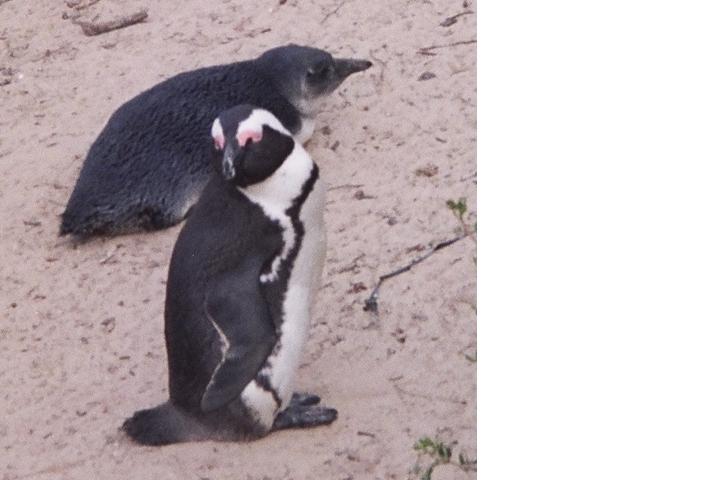
Did you know that there are 17 species of penguins, and that only a few of those 17 call Antarctica home? While visiting South Africa, our tour guide suggested a stop at Boulders Beach to see the penguins. Penguins? In Africa? The idea seemed laughable, but a short walk down the boardwalk revealed hundreds of “jackass” penguins, aptly named for their braying call.

Properly known as African penguins, they live and breed on the coast and off-shore islands. You can see many videos of these penguins on YouTube — here are two of my favorites: Boulders Beach penguins and a “jackass” penguin braying just like a donkey.

Back at the visitors’ center, my misconception was further challenged. Informational displays showed a wide distribution of penguins throughout the Southern Hemisphere - Africa, the Galapagos Islands, South America, Australia, New Zealand, and yes, Antarctica. This interactive map shows the distribution of all 17 penguin species.

It seems that March of the Penguins and Happy Feet only tell part of the penguins’ story. Furthermore, searches for children’s books and lesson plans on penguins primarily focus on those found in Antarctica. No wonder kids (and adults) are confused!

Why teach about penguins?

So why should you fit yet another topic into your already overcrowded science curriculum? Consider this: teaching about penguins may allow you to fulfill standards that are already required. Need to teach about animals’ characteristics, habitats, or life cycles? Does your upper elementary curriculum include studies of reproduction, heredity, or structure and function of living organisms? Or maybe you need lessons on adaptation. Why not use penguins to convey these ideas?

The National Science Education Life Science Standard states that K-4 students should develop an understanding of the characteristics of organisms, life cycles, and how organisms depend on their environments. Can studying penguins and their habitat meet these standards? Absolutely!

The NSES says that students in grades 5-8 should develop an understanding of structure and function in living systems, reproduction and heredity, regulation and behavior, populations and ecosystems, and diversity and adaptation of organisms. Again, teaching about penguins can fulfill these requirements. Additionally, a unit on penguins can also address larger ideas such as how human activities and climate change can impact penguin populations worldwide. (Read the entire National Science Education Standards online for free or register to download the free PDF. The content standards are found in Chapter 6.)

Teaching about the wide variety of penguin species is a great way to capture student interest and target common misconceptions. The theme also easily incorporates literacy skills, geography skills, and mathematics.

Teaching the Science

The SeaWorld Education Department has developed downloadable Teacher’s Guides (pdf files) on the topic of penguins. Each guide includes goals, objectives, vocabulary, hands-on activities integrating science, mathematics, art, and language, and assessment ideas.

In the K-3NSDL Annotation unit, students:

Learn about the variety of penguin species

Create a journal to record facts about penguins

Kinesthetically map the locations of various penguin species

Create a penguin to study adaptations such as coloration

Imitate the locomotion style of penguins

Work cooperatively to create food chains and webs

Simulate an oil spill, its effects, and clean-up

In the 4-8NSDL Annotation unit, students:

Learn about the variety of penguin species

Create maps to show areas inhabited by each species

Create penguin eggs from soap and hatch the penguin inside

Test and compare their ability to jump to that of a penguin

Investigate the insulating qualities of trapped air and feathers

Some activities in the 4-8 unit require mathematical skills that may be too advanced for fourth and fifth grade students. Use these with students needing extra challenge, or omit these altogether.

In addition to this unit, you may want to utilize web resources. The site Penguins Around the World provides a kid-friendly interactive map, an introductory slide show, an online treasure hunt for penguin facts, and two online quizzes.

Suggested Readings

No elementary unit would be complete without suggestions for supplemental reading. Use these books for independent reading time, a class read-aloud, or create a penguin center where students can extend the knowledge gained throughout the unit.

Many wonderful books have been written about penguins. You may already have some of these in your own personal collection, or you can ask your media specialist to help you locate titles. Rather than provide an extensive list, we’ve chosen to highlight a few award winners here.

Antarctic Ice. Jim Mastro and Norbert Wu. Illustrated with photographs by Norbert Wu. Henry Holt. 2003. 32 pp. NSTA Outstanding Trade Book (2004). Recommended ages: Elementary.

The Emperor’s Egg. Martin Jenkins. Illustrated by Jane Chapman. Candlewick. 1999. 29 pp. NSTA Outstanding Trade Book (2000). Recommended Ages: Elementary.

A Mother’s Journey. Sandra Markle. Illustrated by Alan Marks. Charlesbridge Publishing. 2005. 32 pp. NSTA Outstanding Trade Book (2006). Boston Globe-Horn Book Honors (2006). Recommended ages: Elementary.

Mr. Popper’s Penguins. Richard and Florence Atwater. Illustrated by Richard Lawson. Little, Brown Young Readers. 1992. 138 pp. Newbery Honor (1939). Recommended ages: Elementary.

My Season with Penguins: An Antarctic Journal. Sophie Webb. Houghton Mifflin. 2000. 48 pp. NSTA Outstanding Trade Book (2001). ALA Notable Books for Children (2001). Robert F. Sibert Information Book Honor (2001). Recommended ages: Elementary.

Penguin Chick. (Let’s-Read-and-Find-Out Science series). Betty Tatham. Illustrated by Helen K. Davie. Harper Collins. 2002. 40 pp. NSTA Outstanding Trade Book (2003). Recommended ages: Elementary.

Puffins Climb, Penguins Rhyme. Bruce McMillan. Voyager Books. 2001. NSTA Outstanding Trade Book (1996). Picture book. Recommended ages: Emerging readers, Primary.

Literacy Connection

K-3 students can listen to these books as a read-aloud, read independently, or with a partner. They can record facts in a journal or select new words to create a word wall. A science unit on penguins could also simultaneously introduce students to non-fiction text. Students could browse non-fiction books about penguins as well as selected web resources and create Question and Answer books.

Older students can use the non-fiction books to practice research skills. Instead of an individual report, you could create a class ABC book displaying students’ collective knowledge of penguin species and related vocabulary. Education World provides an explanation of ABC books along with samples of student work. ReadWriteThink provides guiding worksheets and a rubric for assessment.

Narrative text can also be used in conjunction with a penguin unit. Students can keep journals while reading Mr. Popper’s Penguins. A detailed instructional plan from ReadWriteThink includes journal questions and background information.

Back to You!

What about you? Do you have a favorite penguin resource, lesson plan, or book that you’d like to share? What about exemplary student work (without identifying information, of course)? This site won’t be at its best unless we have input from you — the people who make these ideas come alive to your students everyday! Please post a comment to this blog with suggestions, tips, or comments.

And of course, please check back often for our newest post, download the RSS feed for this blog, or request email notification when new content is posted (see right navigation bar).

That’s all for now! Until next time, stay cool with this hot topic!

Posted in Topics: Animals, Antarctica, Arctic, Education, Lesssons and activities, Life Science, Mathematics, Reading, Science, Technology, Writing, social studies

View Comments (5) »

Welcome post

Beyond Penguins and Polar Bears Logo

Did you know that we’re in the midst of the International Polar Year, the first since 1958? That probably doesn’t surprise you too much — the results of polar research are in the news almost daily. In addition, images of polar bears and penguins are ubiquitous in our popular culture, appearing in everything from blockbuster movies to soft drink commercials. But how much do we really know about the polar regions? Why are so many people stumped by the old riddle: “Why don’t polar bears eat penguins?” Everyone knows that both are associated with snow and ice and the poles; but many people are not aware that the two animals live at opposite ends of the earth.

This blog is focused on helping elementary teachers become more knowledgeable about the polar regions and providing best practices on how to integrate polar concepts into their teaching. Each posting will begin with “Did you know” and include incredible pictures, tales of adventure, and stories of indigenous people and amazing animals. Ideas for connecting science and literacy through children’s literature, writing prompts, and exemplary science activities will be part of each post.

Where We Are Heading

In March 2008, a free, multimedia cyberzine, Beyond Penguins and Polar Bears, will be launched. The online magazine will be filled with cross-curricular content, vignettes, original stories, and lesson plans, all enriched by interviews with people working and living at the poles, cams and videos of the wildlife on snow, ice, and water, and exchanges between classrooms. Literacy and science will be integrated in all cyberzine features, including alignments with national language arts and science standards. At least two versions of much of the content will be available — K-2 and 3-5. And, there will be tools you can use to create your own issues. The postings from this blog will be an integral part of the cyberzine.

We Need Your Help

We want and need your ideas, suggestions, and observations. What would you like to know more about? What questions have your students asked about the polar regions? Do you have a favorite activity that you would like to share? Please post a comment of your ideas, suggestions, or observations. Please check back often for our newest post, download the RSS feed for this blog, or request email notification when new content is posted (see right navigation bar).

Who We Are

The interdisciplinary team working on this project represent Ohio State University (OSU), College of Education and Human Ecology, the Ohio Resource Center for Mathematics, Science, and Reading (ORCNSDL Annotation), the OSU Byrd Polar Research CenterNSDL Annotation, COSI Columbus, and the National Science Digital Library (NSDLNSDL Annotation) Core Integration team at Cornell University and the University Corporation for Atmospheric Research (UCAR). Content and education specialists from OSU, ORC, Byrd Polar, and COSI will be responsible for creating content as well as adapting and contextualizing existing content. The NSDL Core Integration team will be responsible for the technology tools and dissemination strategies. The Evaluation and Assessment Center at Miami University, Oxford, Ohio will conduct all project evaluation.

This material is based upon work supported by the National Science Foundation under Grant No. 0733024. Any opinions, findings, and conclusions or recommendations expressed in this material are those of the author(s) and do not necessarily reflect the views of the National Science Foundation.

Posted in Topics: Education, Ezine Departments, International Polar Year, Polar News & Notes, Science

No Comments