
 On November 5, 2008, a few days after Barack Obama was elected president, Daniel Edelson wrote an open letter to the man who would soon occupy the White House.
Edelson, National Geographic’s Vice President of Education, delivered an eloquent plea, asking that the new administration “take up the cause of geographic education.”
“The U.S. has done a dismal job of educating our young people about the world and the complex interdependencies that link us to each other and to the natural resources and ecosystems that sustain us,” Edelson wrote, and then asked the president-elect to “make sure that learning about this interconnectedness and how to account for it in decision-making will be part of the education that every student in America receives.”
Two years later
Howtosmile.org recently asked Dr. Edelson what has happened since he sent that letter in 2008. Does Edelson still “see the possibility that the administration will take up the cause of geographic education”?
Edelson replied, “The Administration has two strategies for reversing the narrowing of the curriculum that has resulted from No Child Left Behind. They are looking to increase resources for STEM [Science, Techonology, Engineering and Math] education and for what they are calling a ‘well-rounded curriculum’ which includes social studies, foreign languages, arts, and other subjects.
“Recognizing that geographic content and skills are taught in both science and social studies, they have encouraged us to think of both of these as sources of potential funding for geography education programs….our biggest challenge is that all education reform at the federal level is held up by political gridlock.”
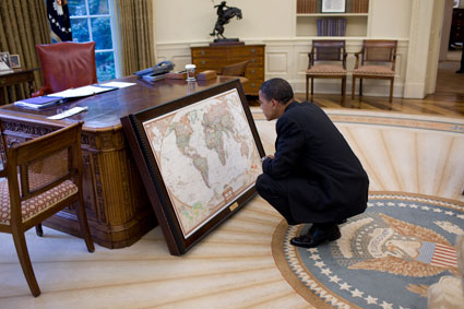
Mapping the President
“With respect to President Obama himself,” says Edelson, “he, like his predecessors in the Oval Office, received a custom-made map case from the National Geographic Society shortly after his inauguration. I have been told by someone who was told by someone else who works in the White House, that the President makes good use of the maps and likes to show them to visitors.”
Read the full article, Maps in the Oval Office, at howtosmile.org.
See also:
Geography Awareness Week (Nov 14 - 20): Boy do we need it
Mapping data to change minds: a lesson from 1854
Where data meets design: spam maps, Science on a Sphere, and zombie survival charts
Image of President Obama in the Oval Office courtesy of the White House.

* You can follow any responses to this entry through the RSS 2.0 feed.